
Pakistan’s Claims Debunked: Independent Analysts and Global Fact-Checkers Expose Lies of Fabricated Strikes on Indian Targets During Operation Sindoor

In the high-stakes theater of modern warfare, the first casualty is often the truth, but in the digital age, pixels don’t lie.
As regional analysts conduct a forensic post-mortem of the May 2025 India-Pakistan conflict, a startling reality has emerged: the “devastating retaliatory strikes” claimed by Islamabad were largely a product of a sophisticated, yet ultimately flawed, disinformation campaign. New geospatial data and independent OSINT (Open Source Intelligence) reports have conclusively debunked the satellite imagery presented by Pakistan’s military as evidence of successful hits on Indian soil.
Operation Sindoor and the Fog of Disinformation
The conflict, sparked by the tragic Pahalgam attack in April 2025, saw India launch Operation Sindoor on May 7. While India’s precision strikes on terrorist infrastructure and key Pakistani airbases like Sargodha and Nur Khan were validated by international agencies, Pakistan’s response, dubbed Operation Bunyan-un-Marsoos, relied heavily on digital fabrication.
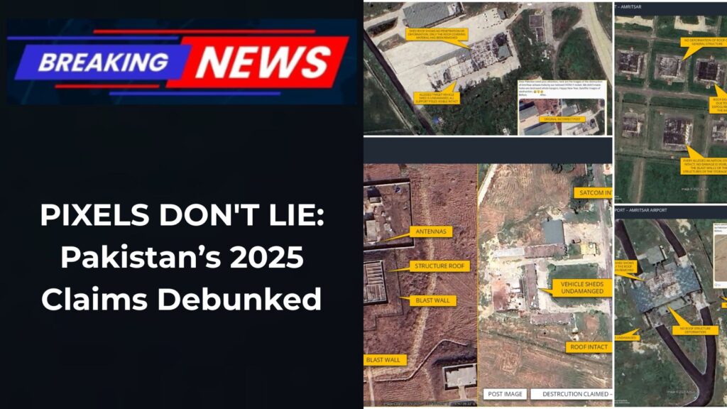
DG ISPR Ahmed Sharif Chaudhary initially presented imagery allegedly showing “smoldering remains” at Indian military installations in Udhampur and Jammu. However, cross-referencing these coordinates with real-time Maxar and Google Earth data from early 2026 confirms that no such damage occurred.
How the Fraud was Uncovered
Independent investigators like Damien Symon and global fact-checking units identified three primary methods of deception used in the Pakistani narrative:
- Recycled Disaster Footage: Imagery presented as “fresh strikes” on the Jammu airbase was traced back to a 2021 MiG-21 crash in Moga and a 2024 accident in Barmer.
- Temporal Inconsistencies: Shadow analysis and vegetation patterns in the “after” photos released by Islamabad did not match the meteorological conditions of May 2025.
- Digital Manipulation: Forensic experts found evidence of “cloning” artifacts in the satellite shots, where craters were digitally superimposed onto untouched Indian runways.
Intentionally misleading images are now being circulated as evidence of Pakistani strikes at military facilities in Amritsar, Punjab, India – verification confirms no such "destruction" is visible at the alleged targets, below are some images correcting this disinformation pic.twitter.com/RYnr1ayxSn
— Damien Symon (@detresfa_) January 1, 2026
Now an image dated 25 MAY 2025 from Jalandhar shows a damaged building within an Indian military complex, only issue is the damage predates the IND-PAK conflict & is visible on low res imagery clearly de-linking it from damage allegedly caused by Pakistan pic.twitter.com/ilB7C8CDj9
— Damien Symon (@detresfa_) January 1, 2026
The “Sargodha Reality”: Verified Hits vs. Paper Victories
While Pakistan attempted to manufacture a narrative of Indian losses, the damage on their side was undeniably real. Maxar Technologies’ year-end retrospective for 2025 confirms extensive structural damage at:
- Sargodha Airbase: Precision hits on hardened aircraft shelters.
- Nur Khan Airbase: Significant disruption to logistics and transport infrastructure.
- Bholari Airbase: Destruction of advanced radar arrays.
In contrast, international observers found zero evidence of impact at the Indian locations Pakistan claimed to have neutralized.
AI and Deepfakes: The New Frontier of War
The 2025 conflict is now being studied as a landmark in “Hybrid Warfare.” Beyond doctored images, the campaign included AI-generated voice clones of Indian officials and deepfake videos of “surrendering soldiers.”
The Indian Ministry of Information and Broadcasting (I&B) established a 24/7 “War Room” during the crisis, which successfully flagged over 500 instances of visual disinformation. One viral clip claiming a strike on Srinagar was actually traced back to sectarian clashes in Khyber Pakhtunkhwa from early 2024.
The Verdict on 2025
The debunking of these claims marks a significant shift in how global audiences perceive military announcements from the region. The reliance on “faked” victories suggests a desperate attempt to maintain domestic morale in the face of verified Indian precision strikes.
For platforms like Totemscroll.com, the lesson is clear: in the era of AI and instant uploads, the truth is no longer found in official press releases, but in the cold, hard data of high-resolution geospatial intelligence.